Let’s be honest here. The world doesn’t work like the U.S. Senate, where every state gets two senators for a total of 100. If the world was actually like the U.S. Senate, our planning for this trip would have been much less complicated – just spend two days in every state.
That would be a pretty terrible idea, however, for the fact that California, New York, Texas and other large states would be underrepresented. We’d be forced to miss out on a majority of what those states had to offer, in lieu of an equal two days in boring, unnecessary places with arbitrary names and borders surrounding them.
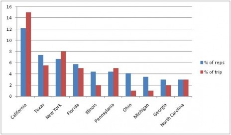
In fact, I think it would be fair to say that our trip more closely reflects the nature of the U.S. House of Representatives, where states are allocated a certain number of elected officials based upon the population of the state from which they hail. We can consider this system in comparison to our process of planning, during which we planned for the most time to be spent in the places with the coolest stuff to see and do. Granted, those aren’t exactly the most scientific of terms, but it’s worth looking at.
Here is a graph about the ten most populated states in the country. The first bar reflects their share of representation in the House, and the second reflects the amount of time we’re spending there.
And the bottom ten:
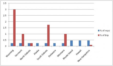
In the meanwhile, I got a comment the other day from a reader telling us how he was excited to see our Rhode Island pictures, as he had grown up there. Sorry to disappoint, but…
But we made it, and now it’s on to Boston.
-Tom